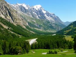
Val Veny
This post is also available in:
 Italiano (Italian)
This valley is at the foot of the Mount Blanc Massif, south of Courmayeur. It was shaped by the Miage and Brenva glaciers and by its river, the Dora of Veny, which joins the Dora of Ferret flowing into the Dora Baltea River.
Val Veny is divided into three main sections (starting from its upper border):
– a section parallel to the Mount Blanc Range, between Col della Seigne (8.241 ft) and the lower part of the Miage Glacier (the largest in Valle d’Aosta: it covers 2.718 acres with a length of more than 6 miles);
– the intermediate section with the grassy plains and the belt of the Val Veny Dora River.
– the entrance to the valley section, dominated by Mount Blanc and the final part of the Brenva Glacier (4.737 ft).
On the right side of Val Veny, near Courmayeur, there’s Lake Checrouit at 7.103 ft of altitude.
On the opposite side, visitors can see the Mount Blanc with “Dente del Gigante” Peak (13.166 ft), and the Brenva glacier (it covers 1.803 acres and it’s the fourth glacier of Valle d’Aosta).
Val Veny can be travelled by car in the summer, thanks to the road that runs to La Visaille (this road is closed in the winter). Along the way, there are refreshment facilities, hotels, mountain shelters, and camping areas.
Chamois, ibex, golden eagles, roe deer and red deer are the most important representatives of the local fauna, also thanks to the presence of a private protection oasis: Riserva Marone Cinzano.
The Saussurea Alpine Garden (the highest in Europe at 7.135 ft – see dedicated page) collects and enhances the natural species of the local flora and other alpine species housed in specifically recreated habitats.
This post is also available in:
 Italiano (Italian)
Contatti
Località Planpincieux - Courmayeur(AO)
0165 869812
info@consorziovalferret.com
